
As discussed in the last post we examined if we could create a food plot and be the primary beneficiary. Now that we know it’s possible, we can look at the other considerations in planning a wildlife food plot.
First you need to define the purpose of your food plots. I often design and plant multipurpose food plots that are used by a wide variety of wildlife – big game, small game, songbirds, and pollinators. That said, I often tailor some food plots for a specific purpose. Included here is having a focus on a particular species, a specific season, or a place that you’ve chosen within your management landscape.
TYPES OF FOOD PLOTS
I generally plant three primary types of food plots. First up are food plots for small game. I have a bird dog and like to release chukars and pheasants for her to hunt. The plots can be single species plantings or mixes containing combinations of grains, sunflowers, and other suitable species. The goal here is to produce a fall food plot that provides food resources and maintains cover well into winter.


The second type of plots I plant are for big game – whitetail deer and black bear. I plan these plots for distinct purposes based on the goal for that food plot. I plant spring plots of fast-growing high palatability species to supply nutrition for deer growth and development, especially lactating does. After these plots wane in mid-August, they are replaced by plantings that mature during November to produce food during hunting seasons lasting into mid-January (in ag production terminology this is known as double planting). Corn plots are for fall feed as they attract deer but I plant them primarily to attract black bears. Clover plantings are long lasting multi-season plots that deer and other species utilize year-round.
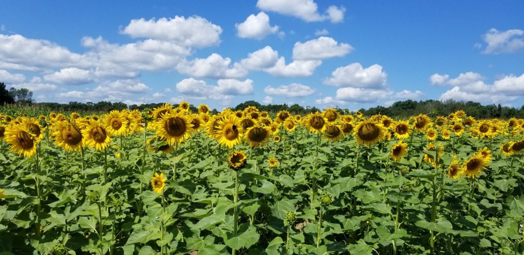
The third type of plots I plant are multipurpose plots. I often plant sunflowers to attract songbirds and pollinators. It’s amazing to observe the number of insects that use sunflower patches, especially bumblebees and small native bees. When these plots go to seed, they feed doves, turkeys, crows, and many species of songbirds. In 2020 I observed standing sunflower heads being fed on by deer and black bears.
As I’ve shown above food plots can be extremely versatile. When you plan food plots you need to determine what you want them to achieve. Once you have a clear objective then you can begin to figure out where to locate a plot, how large it will be, and what crop(s) you want to plant there.
If your food plot is designed to be hunted, which most are, then you need to look at your property and pinpoint those areas that will provide hunting opportunities. Small game plots are often placed near supporting cover bordering woodlands, along brushy areas, or beside vegetated swales. An isolated food plot puts small game at greater risk of predation so avoid that situation. For big game food plots – we’re talking whitetail deer – consider property boundaries, adjacent habitat, deer bedding areas, funnels and corridors, and prevailing winds. Your goal here is to use plots to draw deer to the area you want to hunt and give you shooting opportunities. You need to understand the positive and negative qualities of your property.
A food plot that draws lots of deer isn’t much good if you can’t get to it because of wind direction or if your neighbors are spooking game by riding ATVs near your stand location during hunting season.
If you’ve settled on what type of plot you’d like to create you’re ready to move forward with some serious planning. So, what’s the next step? Creating plan maps for your property. I use sophisticated computer mapping software to create interactive maps for assessing entire properties or specific plot locations. This allows me to view many variables in one place by having multiple layers of specific information that I can project for a specific area.
Do you need to have this one-stop mapping capability? Not really. There are many resources that you can access that will help you in your decision process. We can examine those options later.
MAPPING YOUR RESOURCES
What information do you need for our planning maps? Much of the useful information relates to the resource base at the location(s) you’ve identified. At a minimum you need to include the following:
Current Land Use: Depending on the current land use of your candidate plot location you may or may not need to invest a significant amount of effort to prepare that location for planting. Has this area been in cropland or pasture recently? Is it overgrown with brush and would removing all or some of that vegetation be advantageous? Are you contemplating a plot in a woodlot with mature timber and significant shading? What land use is located next to your plot location?
Topography and Soils: The topography of your site can be critical to its success. If your plot is located on a slope and you plan to till it frequently you may have issues with erosion. If you’re on a steep slope it may be difficult to safely operate machinery. If located at a higher elevation with significant exposure crops may be subject to wind damage or be drought prone. Conversely, low lying areas may be prone to flooding and late frost in the spring and early frost in the fall.
Additionally, soil type can limit food plot productivity. Thin, rocky soils or sandy soils are often difficult to prepare and maintain food plot productivity. Hydric soils – soils that can support wetland vegetation – are often wet (saturated), cold, and nutrient poor making food plots a difficult proposition unless you’re planting species adapted to those conditions.
Landscape Position and Adjacent Habitat: What is the position of your plot in relation to prevailing wind and game travel corridors or funnels? Do you know where deer bedding areas are and how deer would likely come to your plot once established? Are there travel barriers that would limit access to your plot? Could adjacent habitats offer alternative food sources at the same time food would be available in your food plot? Will your plot location be shaded during a significant portion of the day limiting plant growth?
Climate and Growing Season: Determine the USDA Plant Hardiness Zone for your plots. Your zone determines which plants are most likely to grow well at a location. The hardiness zone map is based on the average annual minimum winter temperature and is divided into 10-degree F zones. Know your zone and select crops that will mature in your location.
On-site Assessment: Visually assess and map specific conditions at and near you proposed location. One concern of increasing significance is the presence of invasive species both adjacent to and within the plot location. Controlling invasives can become a very expensive long-term management problem at some locations. These species can aggressively compete with your plantings and some of them are very difficult to eradicate. Look for multiflora rose, non-native honeysuckles, teasel, thistles, Phragmites, reed canary grass, and others. Also, during the onsite assessment look at your ability to get to that site. Walk or drive the route you would take with the equipment you need to prepare, plant, and maintain that food plot.
GETTING INFORMATION
So where can you find all these resources to make meaningful maps useful for food plot planning? If you have internet access, you’re pretty much set.
For current land use find aerial photos for your project location. Up to date air photos can be found on Google Earth and other similar sites. Google Earth is free, relatively easy to use, provides 3D and 2D perspectives, and allows you to make basic maps of your property with available drawing tools. You can search by city, address or by specific coordinates (latitude/longitude).
For examining topography use digital topographic maps that can be downloaded from the United States Geological Survey (USGS). Find topo maps at a scale of 1:24,000 as these provide good detail. You can get paper copies of USGS topo maps although I rarely do that. If you want to get digital maps from USGS go to TopoView (https://ngmdb.usgs.gov/topoview/) and then select view and download. From there you can search by location and it will display the available maps for that area (typically multiple years are available). Once you find your area you can select a year and download a digital map – I prefer their GeoPDF maps.
For soils information the USDA Web Soil Survey is a great source of information. Go to https://websoilsurvey.sc.egov.usda.gov/App/WebSoilSurvey.aspx , open the Quick Navigation bar and enter an address, lat/lon coordinates, or your State and County. Once you find you plot location draw an AOI (area of interest) box to define your area of inquiry. Once you have completed that you can look at a soil map (Soil Map Tab) that shows the soils (type and extent) at your plot. For descriptions of those soils select the Soils Data Explorer Tab, followed by the Soil Reports Tab. Under this tab select AOI Inventory then select Map Unit Description (Brief, Generated). You can now view the soil report which describes each map unit with information regarding slope, drainage class, and hydric soils status among many other characteristics. All of these reports can be saved as PDFs for later use.
For interpreting Landscape Position and Adjacent Habitat the same approach as used for assessing Current Land Use (described previously) via Google Earth can be utilized.
For USDA climate and growing season zone information go to https://planthardiness.ars.usda.gov/. At this site you can enter your zip code for your zone classification and temperature range. You can also select a map of your State to see where zone boundaries are located. Understanding your zone is particularly important if you plan to plant fruit trees.
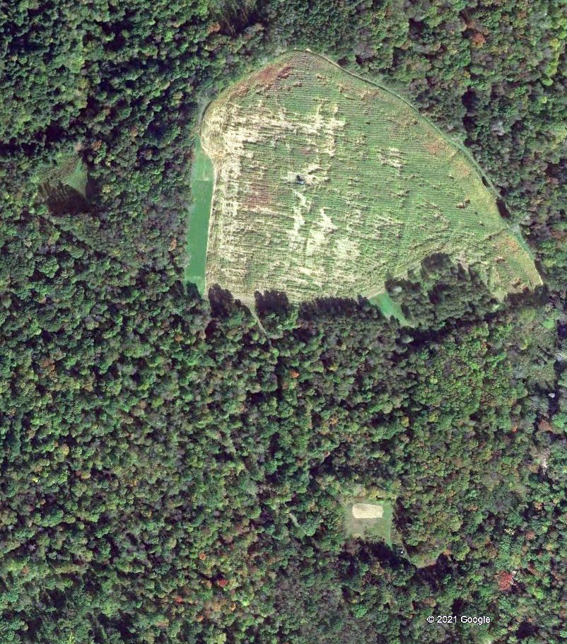
Google Earth Air Photo 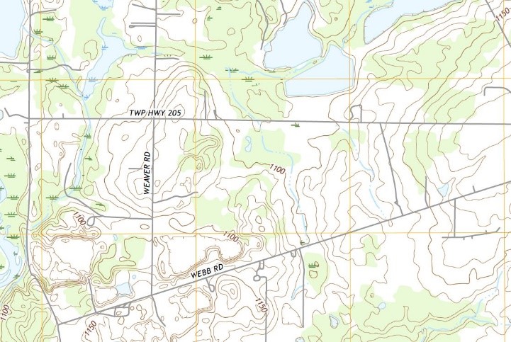
USGS Topo Map 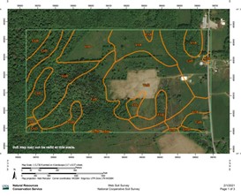
USDA Soil Map
Once you’ve organized and studied all the mapping information you’ve generated, you’ll have a much better feel for whether the selected location is a reasonable site and has the potential to support a food plot. This info also allows you to better develop a plan that considers the pros and cons of your site and what your options are to maximize your chances of having a successful food plot.
Assuming you’ve decided that your site is suitable your next set of questions will revolve around the type and size of the plot, what you want to plant (crop selection), planting requirements (site modifications and amendments), when to plant (season), cost (per plot or acre), and how you will get it done.